(This image is from the Red Rock News in Sedona.)
If you're a UAS (Unmanned Aerial System) owner, Sedona Az might seem like a great destination for flying your aircraft. Beautiful backgrounds, clear air (most of the time), and a great vacation spot, to boot. Here are some of my comments on flying a drone in Sedona.
Sedona has become somewhat infamous for a bunch of signs and maps that have appeared around, and just outside, the city. If you search on the Internet for places to fly a drone in Sedona, here's the image you're most likely to see (most sites link to this image), which was created by the US Forest Service:
It shows the 5-mile radius around the Sedona airport and marks this as a "No Drone Zone."
Whomever created this image does not understand the law. The airspace in and around Sedona is considered a "Class G Airspace." For those unfamiliar with the term, Class G airspace is uncontrolled airspace. Here's the quote from Wikipedia concerning Class G Airspace:
Class G airspace includes all airspace below 14,500 feet (4,400 m) MSL not otherwise classified as controlled. There are no entry or clearance requirements for class G airspace, even for IFR operations. Class G airspace is typically the airspace very near the ground (1,200 feet or less), beneath class E airspace and between class B-D cylinders around towered airstrips.
Radio communication is not required in class G airspace, even for IFR operations. Class G is completely uncontrolled.
VFR visibility requirements in class G airspace are 1 mile (1.6 km) by day, and 3 miles (5 km) by night, for altitudes below 10,000 feet (3,050 m) MSL but above 1,200 ft AGL. Beginning at 10,000 feet MSL, 5 miles (8 km) of visibility are required, day and night. Cloud clearance requirements are to maintain an altitude that is 500 ft below, 1,000 ft above, 2,000 ft horizontal; at or above 10,000 ft MSL, they are 1,000 ft below, 1,000 ft above, and 1 mile laterally. By day at 1,200 feet (370 m) AGL and below, aircraft must remain clear of clouds, and there is no minimum lateral distance.
See https://en.wikipedia.org/wiki/Airspace_class_(United_States) for more details about airspace classes in the United States.
The bottom line is that the area in and around Sedona is uncontrolled (not under the control of an air traffic controller [ATC] or air traffic control tower). It is legal to operate a drone in Class G airspace subject to a certain set of reasonable rules. The Class G rules do not say that you cannot operate a drone within a 5-mile radius of an airport (controlled or otherwise). What they do state is that you must contact the air traffic controller (if any), or make a best effort contact (if there is no active air traffic controller) to inform airport personnel where and when you will be flying. Therefore, the 5-mile radius is not a "no drone zone." It is simply a "you must attempt to contact the airport if you intend to fly here" zone.
Many airports, especially with large residential populations, have been inundated with done flight notifications. The ATCs have (understandably) become annoyed with these requests as they tend to interrupt people who are busy with other things. As a result, many municipal airports simply have a form you fill out on a website to notifiy them when and where you're going to fly. They will respond via email if they have questions about what you're doing, otherwise you've done your "due diligence" and it's okay to fly.
Note that you are not asking for permission to fly in the 5-mile radius. The air traffic controllers can't really deny you permission unless a TFR (temporary flying restriction) is in place. They can suggest that you not fly and they can warn you about air traffic that may create hazards in the area you're wanting to fly in (or more likely, warn you that you will be creating a hazard for other traffic in the area), but they generally do not have the authority to disallow you to fly.
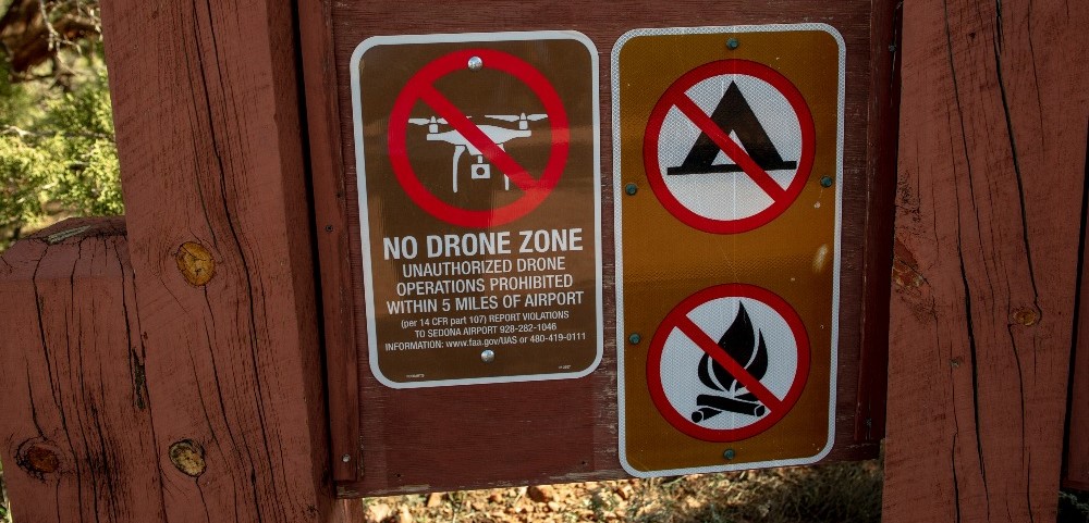
Some ATCs/airports are pretty cool about drones. Once you notify them and assure them you're not doing something crazy, they'll wish you good flying and that's the end of the story. Other ATCs/airport operators get on a power trip and want to disallow anything they aren't controlling in their airspace (which they don't own if it's Class G, but that doesn't stop them from thinking they control it). Apparently, the person(s) in charge at Sedona Airport (at least, circa late 2018) fall into this latter category. These person(s) had the following signs put up around trailheads in the Sedona area:
(This image is from the Red Rock News in Sedona.)
However, neither the airport nor the US Forest service has the authorization to control the airspace around Sedona. Reed Perry, a report for the Sedona Red Rock News published the following story about the dubious legality of these signs:
A week later, a follow-up article appeared:
There was even a brief commentary about this situation in an "Ask Drone U" youtube video:
The interesting comment in the video was something like "The guy at Scotsdale [airport] said this guy [at Sedona] didn't know what he was talking about and to ignore those signs." Pretty damning commentary.
The bottom line is this, the individual(s) at the Sedona airport, on their own, decided to make areas where it is legal to fly a UAS "no drone zones" all on their own. Here's what the second Red Rock News article said about flying drones in Sedona:
Last week, we reported that the “no drone zone” signs that dot trailheads around the Sedona area improperly cited a federal law that does not apply and attempt to impose restrictions on people who fly drones within 5 miles of the Sedona Airport.
In fact, there is no such “zone” and under federal law, pilots can fly their drone aircraft almost anywhere in the Sedona area, regardless of how close they are to the airport.
Drones are still prohibited from flying in the flight path of aircraft or over the helipad at the Sedona campus of Verde Valley Medical Center in West Sedona, and prohibited from taking off, landing or crashing in either the Red Rock Secret Mountain Wilderness Area north of Sedona or the Munds Mountain Wilderness Area east of the city, but not from flying over them.
Other than that, according to the Federal Aviation Administration, drones can fly unrestricted in Sedona’s Class G airspace, which extends from the ground up to 700 feet above. Under federal law, recreational drones can fly up to 400 feet.
-- CHRISTOPHER FOX GRAHAM Dec 7, 2018
According to the article, the US Forest Service has removed the signs. Therefore, you won't be acosted/intimidated/annoyed by drone-haters who see the signs and figure you're doing something illegal.
First of all, if you're going to fly drones within a 5-mile radius of the airport, you should contact the airport and let them know what you are doing. Fortunately, the Sedona-Oak Creek Airport Authority has a form on their website you can fill out to notify them. Here it is:
Fill out the form, ship it off, and you're good to go; you've done your due dilligence.
Sedona, Az, is full of really rich people and movie stars who don't appreciate drones flying over their properties and taking pictures of them (e.g., paparazzi). Don't be a jerk, don't fly over private property (even above 100ft, where it is probably legal to do so). If you're going to fly a drone, be responsible -- don't ruin it for the rest of us. Fly in unpopulated areas, away from crowds and away from residential areas. Keep in mind, if your drone crashes, you don't want it to be in a crowd of people or in someone's back yard.
Right off the bat, there are several places in Sedona any responsible UAS operator will avoid. Probably at the top of the list is Bell Rock. Yeah, this is a great place to orbit a drone around. However, Bell Rock is crowded with people almost year-round, it's not an appropriate place to fly drones. Use your hand-held still or video cameras for shots of Bell Rock. Purchase a professional fly-over video if you absolutely have to have one.
Keep in mind that there is a lot of air traffic in Sedona. There are a lot of helicoptor tours that fly around the Red Rock area. Never fly high (I'd keep it below 200' as much as possible) and if you hear a nearby aircraft, bring your UAS home (or at least way down in altitude). Altitude is an mountanous areas; at one point you're 200' above the (crest of the) mountain, 100' horizontal later and you're at 600' above ground level (AGL). You are violating the rules at that point. Bottom line, avoid going well above the crest of a mountain. Aircraft have to maintain 500' above the crest (which is why the 400' rule exists for drones), but sometimes they fudge that. So be cautious.
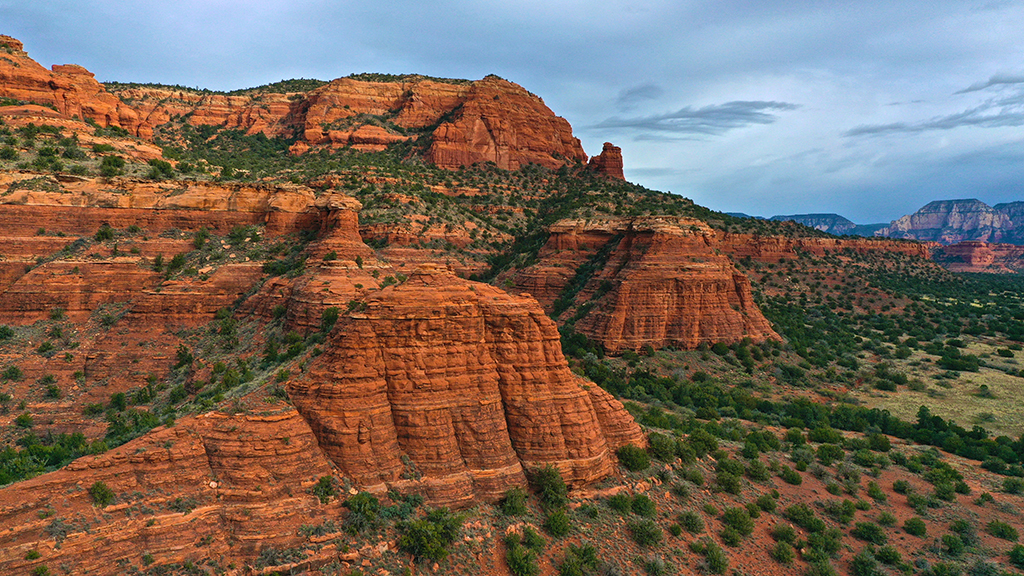
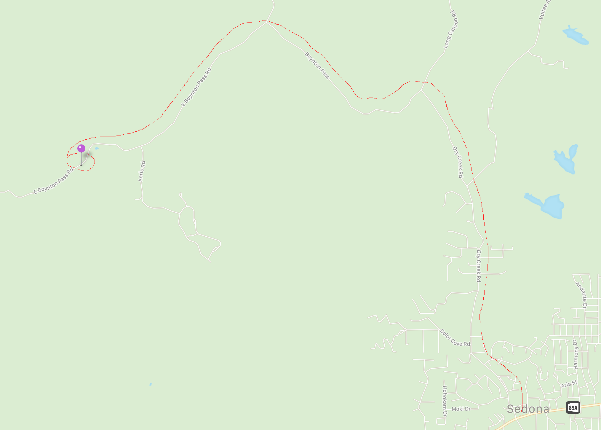
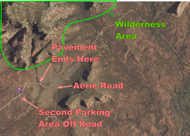
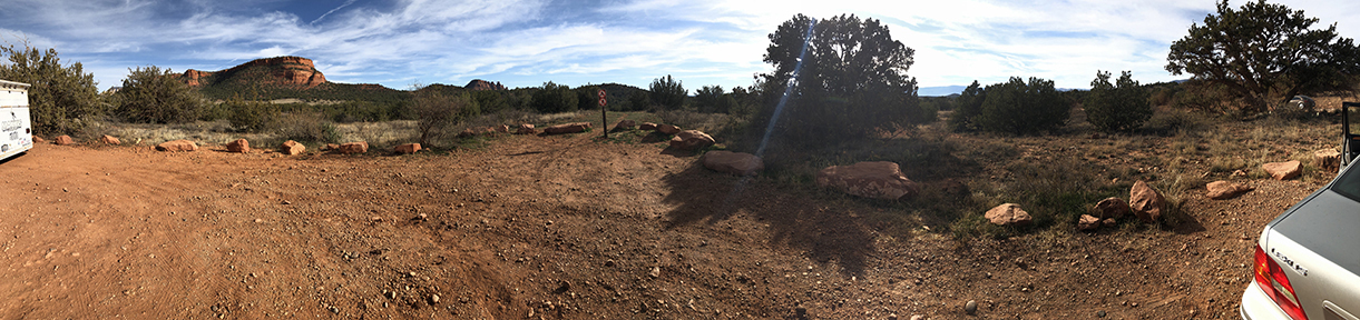
I recently made a trip to Sedona and I found a decent place to fly drones. It's beyond the 5-mile radius of the Sedona/Oak Creek airport (so no notification is necessary), it's out in the wilds (no residential areas around, and probably a half mile, or so, from the nearest trailhead). It has nearly 2000' line of sight in nearly every direction, and there is a lot of level ground (so you can fly farther without having the drone leave visual site). The wilderness area (no drone launching, landing, crashing) is about 1,500-2,000 feet away. Close enough to fly up to and get great pictures of red rocks. Furthermore, there is a lot of Jeep, motorbike, and ATV traffic on the dirt road next to parking area. So no one will complain about drone noise in the wilderness area. There are still some red rocks nearby you can shoot pictures of, to prove you were flying in Sedona.
To get there, turn North on Dry Creek Rd of 89A in West Sedona. Drive (for a while) until you get to Boynton Pass Rd (Dry Creek dead ends into Boynton Pass Rd). Turn left and drive for a mile or so to E Boynton Pass Rd. Turn left again. Drive for a couple of miles until the pavement ends (about a quarter mile past Aerie Rd.). Within an eighth to a quarter of a mile, you'll pass a parking area, small trail, on the right and then come up on a small trail/parking area on the left. Park there and fly your drone. Happy flying!
Panorama of parking area.
Picture taken from a Mavic 2 Pro near the wilderness area (probably about 1,500 ft from the parking spot).